After about 1 hour and 15 minutes flight from Manila, you can now finally caught a glimpse of the northernmost province of the Philippines and from the air, one can see the fields that look like a labyrinthine patchwork of green bordered by tall hedgerows of grass, reeds, piled stones and trees which serve as a crop protection from the fierce winds, and typhoons which commonly pass near the islands as well as huge waves that crash into dramatic cliffs and rocks that jut out into the ocean, which undoubtedly look incredibly similar to the English moors and Scottish Highlands with a Filipino twist. Think Wuthering Heights and you’ll know what we mean. In 1687, English freebooters with a Dutch crew arrived in these islands and named three of the islands in honor of their monarchs- the main island of Batan was named Grafton Isle after Henry Fitzroy, First Duke of Grafton; Sabtang was named Monmouth Isle after James Scott, First Duke of Monmouth and Itbayat was named Orange Isle after William of Orange. The freebooters were led by William Dampier who stayed on the islands for three months but never claimed the islands for the British crown.
Batanes is bordered by the Pacific Ocean to the east, South China Sea to the west, Bashi Channel and Taiwan to the north and the Balintang Channel to the south. It is composed of 11 islands, of which Itbayat, Sabtang and Batan Islands are inhabited while Ditarem, Adekey, Vuhus, Misanga, Dinem, Mavudis and all others are uninhabited.
Early in its history, Batanes already had a civilization flourishing on its islands and was ruled by powerful chiefs who exacted revenues, administered justice, as well as exercised military might especially during times of invasion from other tribes. The idjangs or fortresses of pre-colonial Batanes can still be found all over the islands and they are usually perched on hilltops like the ones that we have seen on Sabtang and Batan Island (Itbud). The idjang in Savidug on Sabtang Island is considered to be one of the most perfectly shaped and the most beautiful among all the Batanes idjangs. Apparently, experts have noted how these idjangs are pretty similar to the gusukus found in Okinawa, Japan. The ancient Ivatans who are Austronesian in origin lived on these idjangs since they first migrated into Batanes about 4,000 years ago during the Neolithic Period. It was during the Spanish Inquisition and the Spanish governorship was established along the coastlines and lowlands which forced the early Ivatans- the people of the islands, to come down from their idjangs and convert to the new system of government. It was around 1686 and 1719 when Dominicans sent expeditions to the islands to proselytize and by 1773, the Ivatans became subjects of the Spanish King. It was only in June 26, 1783, over two centuries after the formal colonization of the Philippines by Miguel Lopez de Legaspi, when Batanes was formally annexed to the Spanish Colonial State under Governor Jose Basco y Vargas. The capital town Basco, obviously got its name from the Spanish Governor General’s surname.
Batanes also boasts of stretches of white and cream colored sandy beaches, probably the most famous of which is the Nakabuang Beach on Sabtang with its often photographed stone/rock arch formation where picnics are usually held during the summer months. The smaller White Beach and the nearby Blue Lagoon in Mahatao offers pretty views as well. Swimming is unsafe in Blue Lagoon however, that is if you don’t want to get smashed into the massive rocks while White Beach is a good and passable beach in our opinion . A private beach, Disvayangan has a row of private picnic houses for rent. Diving (www.divebatanes.com/) is also possible in Batanes with Duvek Bay in Sumnanga having one of the best coral conditions in Batanes as well as in Siayan Island about 5.5 nautical miles from Itbayat which is surrounded by beautiful white beaches and rich coral which teems with abundant marine life.
Itbayat, the northernmost inhabited island in the Philippines, however, does not have any beaches as the entire island is basically surrounded by cliffs. There are other interesting islands in the area, however, they are better reached during the summer months as travel from islands can take a lot of time and the waves can be treacherous.
The formidable looking mountains and hills of Batanes are a great challenge to mountaineers. Mount Iraya on Batan Island rises to about 1,009 meters above sea level and is the highest peak on Batan Island and its spring water is the main source of water for Basco. A good climb for mountaineers, it is also home of the Batanes pit viper, an arboreal snake found only in Batanes and one of the rarest snake species in the world. The Batanes Pit Vipers live on trees and produce their young from eggs hatching within their bodies. They are typically green in color with some others having yellow, black, orange or red markings. Mount Iraya is also home to an abundant number of endemic species of flora and fauna. Some of the flora and fauna that can be found in Batanes are the Indochinese Shrew, Ryukyu Flying Fox, Asian Water Snake and plants like the Voyavoy (a Philippine date palm which is used to make another iconic Batanes item- the Vakul- the traditional headgear for women who use them to protect themselves from the sun, and the rain; the men use the traditional vests called Kanayi and the Salakut as a hat), Kanarem, and Vuhuan. The entire province was declared as a protected landscape and seascape by the Philippine government in 1992.
TOURIST ATTRACTIONS/DESTINATIONS
BATAN ISLAND – is the most populated island of the province. It is composed of four municipalities namely Ivana, Mahatao, Uyugan and the capital, Basco, is the seat of commerce, education and provincial government.
SABTANG ISLAND - is a 30- minute rocky ride from Ivana Seaport on a round-bottomed falowa, fourteen-kilometers southwest of Batan Island. It has intermittent sand beaches and is dominated with steep mountains and deep canyons with small level areas sporadically found along the coastline. It is one of the most beautiful islands in Batanes. Visit Chavayan and witness the rolling of the seven waves: Sumnanga or the Little Hongkong; Nakanmuan, the fishing Village; watch the “Kuyab” or Migratory Birds from China that flock by the hundreds during the month of October.
ITBAYAT ISLAND - has the Sarokan Cave, the orchids that abound in the island to discover and the burial caves to see. It is four hours away by Falowa from Basco Seaport. The island is surrounded by massive boulders and cliffs rising from 20-70 meters above sea level. Shaped like a giant bowl; it is the least visited island of the province. It has no beach and no pier. It has a dirt airstrip for private aircraft and a “regular ferry” runs the Batan-Itbayat route.
Y’AMI - is the northernmost island of Batanes where one can see Taiwan on a clear day. “Tatus” or coconut crabs abound in the island, which is surrounded by rich marine life.
BASCO
01. MT. IRAYA is a dormant volcano standing at 1,517 meters above sea level. It is good for mountain climbing and trail blazing and is a few kilometers from Basco. Its last eruption was in 505 AD and has become the source of fertile soil in Basco and parts of Mahatao.
02. RADAR TUKON is an abandoned United States weather station located on a hilltop and is only 2.75 kilometers away from Basco. It offers a magnificent 360-degree view of Batan Island, the South China Sea, Mt. Iraya and Basco proper on one side and boulder lined cliffs and the Pacific Ocean on the other side. At present it houses the Basco Radar Station.
03. KANYUYAN BEACH PORT at Baluarte Bay in Basco is the port of call of cargo ships bringing goods from Manila.
04. SONGSONG IN CHADPIDAN BAY is an hour of exhilarating trek from Basco proper and offers a beautiful sunset view of Batanes.
05. STO DOMINGO CHURCH was built in 1812 under the supervision of the Dominican friars. It is one of the first limestone buildings to be built under the Spanish regime. The convent beside the church was built in 1814. Buildings in Batanes are traditionally two storey LIME AND STONE HOUSES AND CHURCHES with meter-thick cogon roofs believe to last about 60 years. These buildings were built around 1795 with the help of imported masons, stone cutters and carpenters from Cagayan.
06. NAIDI HILLS is walking distance from Basco proper.
07. VALUGAN BAY has a kilometer long stretch of fine white beach with multi-colored rocks and is only three kilometers from Basco proper.
08. FUNDACION ABAD or PACITA ABAD MUSEUM - home of the world renowned artist Pacita Barsana Abad is now open for publc viewing, it houses her paintings located at Brgy. Chamarian-Tukon. It is a Pension House with de luxe facilities.
MAHATAO
01. SAN CARLOS BORROMEO CHURCH was completed in 1789 and still retains its centuries old features. It has been declared by the National Historical Institute as Heritage Site
02. CHAWA CAVE is for the adventurous. An enchanted cave with natural salt beds whose mouth opens to the South China Sea and is accessible through the boulders of Chawa Point. It is four kilometers from Basco.
03. SITIO JURA AT RACUJAIDE is the Fishermen’s Village in Mahatao located along the Mananoy bay. Within the area is the legendary spring of youth and crystal cave with living limestone formations and RACUJAIDI old settlements.
04. DIATAY BEACH is a cave with multi-colored rocks and white sand located along the highway of Mahatao conducive for swimming and excursions.
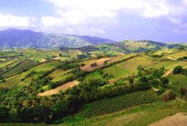
05. COMMUNAL PASTURE LAND is 25 minutes on good road from Basco. Also called RACUH A PAYAMAN, it offers a panoramic view of the hills and the sea; in this area, the cows outnumber the people.
06. WIND TURBINE FARM SYSTEM - installed at Mt. Sumhao in Mahatao was launched on August 7, 2004. It is the first commercialy operated hybrid system in the Philippines. The three units of 60-kilowatt wind turbines complement the diesel generator system that Batan Island is using.
IVANA
01. RADIWAN POINT and IVANA SEAPORT are historical spots where the Katipuneros landed in 1898. It is also the ferry station of falowas plying the islands of Sabtang and Itbayat.
02. SAN JOSE CHURCH was built in 1814. It has a crenellated fortress-like campanile. The church faces the Ivana Seaport where an Honesty Shop is open for buyers who get their goods and leave their money on a wooden box.
03. MT. MATAREM is an extinct volcano 495 meters at its summit.
04. WHITE BEACH at Vatang, Hapnit and Mavatuy Points.
05. HOUSE OF DAKKAY
is one of the oldest houses in Ivana open to visitors who sign the guest book and give donations and take pictures.
UYUGAN
01. RUINS OF SONGSONG is a ghost barangay, which feature a cluster of roofless shells of old houses abandoned after the tidal wave that hit the island of Batan in the 50’s and is a one hour road trip from Basco. It has a good stretch of beach recommended for swimming.
02. OLD LORAN STATION used to house a US Coast Guard detachment for almost two decades and is only 45 minutes from Basco on good roads.
The Beauty of Batanes is unique. No wonder other people who visited Batanes said it is just like new Zealand. Batanes is also said to be the perfect place for relaxation and escape from the city life. The enchanting air. The colors attractive colors of the leaves and the sea. The steep cliffs and the rolling hills and also the border-lined and specially the unique architecture of the houses are the ones noticeable. Ivatans are also said to be honest, gentle and polite but brave and lastly, Ivatans are proud of their land and heritage. There a lots of things to do in Batanes like to swim on the beach, fishing, Biking, Hiking, island hoping and to reflect and admire the unknown beauty of Batanes.


URL:http://en.wikipedia.org/wiki/Batanes, http://mandy-navasero.blogspot.com/2011/04/honesty-cafe-in-ivana-batanes-photo.html, http://www.virtualwanderer.info/tag/batanes/, http://pedallingmadlybackwards.blogspot.com/2012_04_01_archive.html
http://tourism-philippines.com/batanes/
http://www.travelandtourpackages.com/tag/batanes-tour-packages/
http://tourism-philippines.com/batanes/
http://www.travelandtourpackages.com/tag/batanes-tour-packages/